


![]()
![]()
PLEASE NOTE: It is illegal to tie to a buoy IN ANY CIRCUMSTANCE other than an emergency. When someone ties to a buoy, there is a chance the buoy will be dragged to the stump line and render it dangerous.
BUOY PROBLEMS: Any boater noticing problems with buoys can call the SRA Louisiana and ask for Mike Carr. Report the problems and it will get corrected. Please report problems such as floating logs in lane, buoy that has been moved, missing or damaged, directional buoy with missing sign, etc. SRA-LA Office Phone: (318) 256-4112 E-Mail: Mike.Carr@la.gov If you are not speaking with someone directly, please remember to give all the details you can aabout the problem and location of the problem.
Introduction:
As of May 1, 2004, Toledo Bend Reservoir had 2,000 marker buoys and 183 miles of marked boat lanes.
As of February 17, 2010, the boat lanes and buoy marker system has been changed. The purpose of this page is to provide you with information on the buoy marker system, boat lanes, and changes now in effect, having been made by the Sabine River Authority (the agency responsible for the buoys).
There are now approximately 10,000 buoys marking the 183 miles of boat lanes, with the main north/south lane marked on each side of the lane and the secondary north/south and east/west lanes marked in the middle of the lanes.
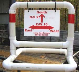
Approximately 90 directional signs are being installed, one at each boat lane intersection. These directional signs will provide not only information as to your location, but will be a safety measure should you break down in inclement weather and need to relay your location to someone for help. All of these directional signs coincide with the lake maps that are available for purchase in this area. With the new directional signs and a lake map, navigation of Toledo Bend Reservoir will be vastly improved.
Pictures:
There are pictures at the bottom of the page showing the new markers, one of the SRA buoy tenders, samples of directional signs, and a map of the lake and boat lanes.
Boat Lane Width:
Main boat lanes (usually North/South) are generally about 100′ wide. Secondary boat lanes (usually East/West) are generally 30′ – 40′ wide.
North – South Boat Lanes:
The lake has over 70 miles of North/South boat lanes. All North/South lanes are marked on both sides of the lane. The North/South lanes generally follow the course of the Sabine River. Especially in the north part of the lake, the boat lanes may be somewhat winding – caution must be used to follow the lane and not “cut through” a curve as the area not in the lane is likely to have standing timber that may damage your boat.
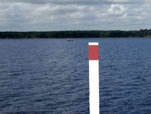
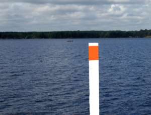
- New Markers: The new markers are 4″ diameter white PVC pipe with either a red or green stripe on them (Red is for the East/Louisiana side; Green is for the West/Texas side). The new markers are about 150 feet to 200 feet apart.
East – West Boat Lanes:
All East/West boat lanes are marked with a single row of buoys in the center of the boat lane. Generally these lanes are 30′ – 40′ wide. CAUTIONARY NOTE: Please note that since the East/West lanes are marked with a single line of buoys and the lanes are generally not as wide, you should make it a habit to always run your boat on the windward (The side FROM which the wind is blowing) side of the buoys. Why? The buoys need enough slack in the lines mooring them to allow for the lake to be at its maximum level. When the lake is lower, there is slack in these lines and the wind will cause the buoys to float to the leeward (The side TO which the wind is blowing) side of the lane. Since these lanes are only 30′ – 40′ wide to start with, this can possibly leave a buoy at the very edge of the lane and as your boat goes by it if you are on the leeward side, it may be out of the lane and in danger. Staying on the windward side means you will always be in the lane. Since the North/South lanes are wider and marked both sides, this is generally not a problem with them.
- New Markers: The new markers are 4″ diameter white PVC pipe with a red reflective stripe on them. The new markers are about 150 feet to 200 feet apart.
New Boat Lanes:
The SRA no longer has stump cutters and is, therefore, no longer clearing new boat lanes. HOWEVER, if someone cuts or has a lane cut and contacts SRA and SRA deems it safe, SRA will mark and GPS the lane and maintain it.
Safety Of Boat Lanes:
All lanes are safely navigable down to the new low lake level of 168 MSL. Caution should be used if the lake falls below that level!
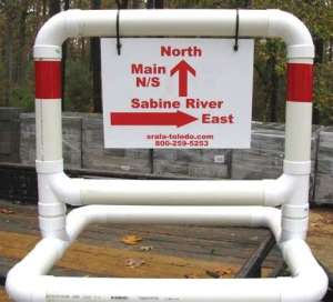 | 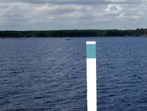 |
| Sample Directional Sign | New Green North/South Buoy |
 |  |
| Sample Directional Sign | New Red North/South Buoy |
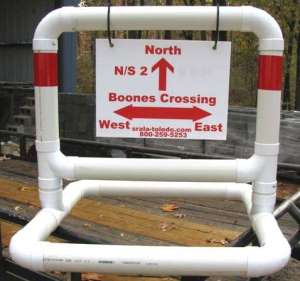 |  |
| Sample Directional Sign | New Red East/West Buoy |
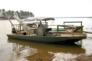 | |
| One of the buoy tenders used by SRA to maintain and replace marker buoys | |