


![]()
![]()
Sabine River Float Trips
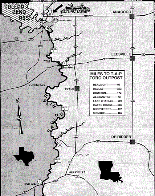
Sabine River Map and Trip Descriptions
Section IA
Most Popular stretch with best fishing for striped and largemouth bass, and catfish. Not as many sandy beaches as the lower section but adequate. The only rapid is in this section just above Sandy Creek. Class I or II depending on water flow. At high water the rapid is washed out. Runyon Hills is located in this section at mile 7. Bald eagles have been sighted in Sections 1A and 1B.
Distance: 10.5 miles from put in at Generator Canal to take out at Hwy 8 just above bridge crossing on river left. Float Time: approximately 4 – 5 hours.
Section IB
Altemate put in for section 1A. This is the Old Sabine River that was dammed when Toledo Bend Reservoir was made. It gets its flow from Toro Bayou and 144 CFS always released from the Toledo Bend Flood Canal. This put in adds 3 miles to the length of Section 1A. Like Section 1A, fishing is good. Striper bass fishing is best upstream aproximabely 1 mile.
Caution: Due to the effect that the generators have, at certain times the current flow is upstream. This section of the Old Sabine River is referred to by the locals as Yo-Yo Bayou.
Float Time: approximately 5 – 6 hours.
Distance: 13.5 miles from Hadden’s Ferry to take out at Hwy 8 just above bridge on river left at Burr Ferry.
Section II
Longest stretch with many beautiful white sand bars offering numerous primitive camp sites at low or normal water levels. This is an undeveloped and isolated area so pack accordingly. Plan to spend two days in this section.
Distance: 28.5 miles from Burr Ferry to Anacoco Bayou just past private camps at end of road on river left. Float Time: Approximateiy 12 – 14 hours.
Section III
Outer limits, the last stretch of the river that Tack-a-paw services, is much the same as above with beautiful scenery characteristic of East Texas and West Louisiana. Distance: 11.3 miles from put in at Anacoco Creek to take out at Hwy 190 just above the bridge on river right (Bon Wier).
FloatTime: Approximately 4 – 5 hours.