


![]()
![]()
The Toledo Bend Dam was planned for many years before it became a reality.
Twelve years of study and planning were culminated October 5, 1961 with groundbreaking ceremonies officially launching the $60,000,000 Toledo Bend dam and reservoir project on the two-state boundary portion of the Sabine River.
In any project as large and complex as construction of the Toledo Bend dam and reservoir and hydroelectric facilities, first things must come first. In fact, there was orderly scheduling of work over the estimated four years necessary to bring the project to completion.
In order that an orderly completion of all work might be achieved within the planned construction period, it was necessary to initiate work on land acquisition, relocations of highways and other facilities, and clearing of certain reservoir areas.
The general plan of construction, as originally contemplated, required that excavation for the spillway and power house be the first step to be undertaken at the damsite. Earth removed in construction of the spillway and power house were used in the embankment, which meant construction of the dam actually began with the earliest excavation on the project.
Clearing of the damsite, spillway and power house area, test borings, and on-the-ground surveying and staking preceded the beginning of earth-moving operations.
Water flow in the river bed was cut off by construction of small buffer dams just above and just below the damsite, during the normally dry months of July through October, thus permitting heavy earth-moving equipment to fill and compact the final gap in the huge embankment.
In connection with land acquisition, a timely and orderly removal of merchantable timber was necessary. Clearing operations commenced after removal of the timber. All work of this nature in the reservoir was completed prior to commencing closure of the dam. Approximately 20,000 acres of timber were permanently submerged, and another 30,000 acres had various degrees of submergence. Commercial timber was harvested prior to completion of the project.
Of the total reservoir lands, about 56 percent or 101,600 acres lie in Louisiana and the rest of 44 percent or 80,000 acres in Texas. In Texas, the reservoir is in Sabine and Shelby Counties, with a small area in Newton County.
No towns or extensive improvements lay within the reservoir area, although there were some rural dwellings, stores, churches, and cemeteries in the area. All cemeteries were moved to higher ground. About 35,000 acres of the Sabine National Forest lay within the proposed Toledo Bend Reservoir area, all of it on the Texas side.
The ground breaking ceremony for Toledo Bend Dam was held on October 5, 1961.
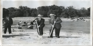
Two Southern state governors Price Daniel of Texas and Jimmy Davis of Louisiana stood side by side on the leading edge of a history-making epoch as they dug the first official spades of earth in an impressive beginning of the gigantic Toledo Bend dam and reservoir project which was to cost up to $60,000,000 to complete and put into operation.
In spading the sand on the two shores of the Sabine River at Hadden’s Ferry, Governor Davis and Governor Daniel thrust the sharp pointed spear of progress into the greatest single fresh water development project ever undertaken in the two-state region.
The pleasant autumn air crackled with applause as numerous dignitaries representing Texas and Louisiana lauded the Toledo Bend project as the turning point to a new era of expansion and development of the economic potential of a large area on both sides of the Sabine.
A crowd of exuberant citizens from both states packed a pointed bluff jutting into the Sabine River about a mile south of the actual dam site. A wilderness area without roads, the dam site was inaccessible to officials and the large crowd.
Governors Daniel and Davis literally joined hands across the Sabine River, to perform traditional ground breaking on the Louisiana side first and then moved across the water by boat to duplicate the ceremony on a sandy Texas beach.
The dedication ceremony for the completion of the Toledo Bend Project was held on October 11, 1969 just eight years and six days from the time that the ground breaking ceremony was held. The ground breaking had been on the Louisiana side of the Sabine River and the dedication ceremony was held on the Texas side.
Some 1,000 persons gathered Saturday morning, October 11, 1969, at Toledo Bend, to witness the official dedication of Toledo Bend Dam and Reservoir.
The realization born of an idea twenty years ago, and actually started construction eight years ago, was a joint effort of two states’ combination of will, fortitude, know-how, money, and determination. Toledo Bend hydroelectric power reservoir is the only such in the nation built without federal assistance. The 1,200-mile shoreline borders on Texas and Louisiana, and it was through the cooperation of those two states that Toledo Bend Dam and Reservoir stands today. Masters of the ceremonies for the celebration were the presiding officers of the two state’s river authorities involved in the project. Gov. Preston Smith and Gov. John McKeithen of Louisiana led the list of dignitaries at the dedication, and did the honors of unveiling the plaque, turning on the turbines, and expressing their pride and appreciation.
The project was blessed by holy water from the great bend in the Tajo River in Toledo, Spain. The Archbishop of Toledo blessed the water sent to Toledo Bend especially for the occasion. Ft. Polk’s Army Band provided music for the ceremonies.
| Toledo Bend Reservoir | |
|---|---|
| Location | Texas / Louisiana |
| Coordinates | 31.1965°N 93.5721°WCoordinates: 31.1965°N 93.5721°W |
| Lake type | reservoir |
| Primary inflows | Sabine River |
| Primary outflows | Sabine River |
| Basin countries | United States |

State and national figures, as well as ordinary citizens, shared in the happiness and pride of the day.
| Welcome | Calvin T. Watts |
| Invocation | Honorable Joe Cooper |
| Introduction- Board of Commissioners, Sabine River Authority, State of Louisiana and Louisiana Dignitaries | Calvin T. Watts |
| Introduction- Board of Directors, Sabine River Authority of Texas and Texas Dignitaries | Charles T. Wickersham |
| Recognition of Special Guest | John W. Simmons |
| Presentation of Honorable John McKeithen, Governor, State of Louisiana | Leon Gary |
| Dedication Address | Governor McKeithen |
| Presentation of Honorable Preston Smith, Governor, State of Texas | Charles T. Wickersham |
| Dedication Address | Governor Smith |
| CONSECRATION OF WATER FROM TOLEDO, SPAIN GOVERNORS THROWING SWITCH TO START POWERHOUSE | |
| Benediction | Honorable Dudley Davis |