


![]()
![]()
Toro Bayou Map and Trip Descriptions
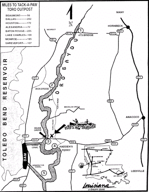
SECTION I
Remote and Natural, this area offers good fishing, petrified wood and rock hunting and five rock shoals. It is the best section for overnight camping or hiking. Due to the length and remoteness we require at least 2 canoes on this section and recommend it for experienced canoeists only. Distance: 11 mile stretch from Hwy. 473 Bridge to Toro Iron Bridge. Float Time: Approximately 5 hours with optimum water level. The best time to canoe this strip is from early spring to mid June. Optimum Level: 17 inches at Hwy. 392 Bridge water gauge. Minimum level is 10 inches.
SECTION II
The most popular section is #2 with many rock falls, sandy beaches and Macevla Creek, great for explorers and overnight campers. Ideal section for large groups (church outings, etc.) that contain both younger children and older adults. Distance: 5.6 miles from Toro Iron Bridge to Hwy. 392 Bridge. Float Time: Approximately 3 hours at optimum level. Optimum Level: 14 inches at Hwy. 392 Bridge water gauge. Minimum level 6 inches.
SECTION III
Striper bass fishing is ideal! Confusion of the warm, easy flowing Toro, with the cold swift water of the Sabine and flood canal, creates a mixture that is ideal for bass fishing. Add to this the rock falls and Section III offers not only contrasting river flow, but terrain as well. Due to the fluctuating water level in this section, take out at Hadden’s Ferry may not be good. Distance: 3.4 miles from Hwy. 392 Bridge to Hadden’s Ferry. Float Time: Approximately 1.5 hours at optimum water level. Optimum Level: normally is 16 inches. If the generator gates are open you may find yourself paddling upstream. Minimum level is 10 inches.